


sure

Pieeet
User
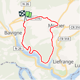

Length
6.1 km

Max alt
424 m

Uphill gradient
144 m
Km-Effort
8 km

Min alt
328 m

Downhill gradient
144 m
Boucle
Yes
Creation date :
2014-12-10 00:00:00.0
Updated on :
2014-12-10 00:00:00.0
--
Difficulty : Unknown

FREE GPS app for hiking
 SityTrail
IGN / Geographical institutes
SityTrail Plus
The world is yours!
About
Trail Walking of 6.1 km to be discovered at Unknown, Canton Wiltz, Lac de la Haute-Sûre. This trail is proposed by Pieeet.
Description
le long de la sure
Positioning
Country:
Luxembourg
Region :
Unknown
Department/Province :
Canton Wiltz
Municipality :
Lac de la Haute-Sûre
Location:
Unknown
Start:(Dec)
Start:(UTM)
704909 ; 5534133 (31U) N.
Comments